the Balboa Peninsula
The Balboa Peninsula, also known as the Newport Peninsula, is a piece of land stretching from Pacific Coast Highway (PCH), east southeast for about 4 miles along the Newport Beach coastline. The interior bay front of the peninsula defines the southern harbor boundary of Newport Bay, aka Newport Harbor.
When touring the Balboa Peninsula, enter from either Balboa Blvd. off Pacific Coast Hwy - or on Newport Blvd. where the PCH Bridge deposits you after crossing over Pacific Coast Highway.
The Balboa Peninsula is the most substantial piece of Real Estate in the greater Newport coastal area and includes two major commercial districts, each anchored by one of two piers - the Newport Pier, about a third of the way down the peninsula, and the Balboa Pier approximately two thirds of the way down the peninsula.
Although the peninsula is a residential and commercial ecosystem in and of itself, it is the largest part of the greater coastal Newport Beach recreation and residential area. Also a part of this greater area is Newport Harbor and a number of islands or "isles."
Within the boundaries of Newport Harbor , also called Newport Bay, are two substantial neighborhood islands
Lido Isle at the west end and Balboa Island toward the east end. Lido Isle has no significant commercial presence
however, Balboa Island has an interesting and historical commercial district running along Marine Avenue just after crossing the bridge onto the island from Bayside Drive.
Balboa Island was created from deposited sediment when the newport bay was dredged in the early part of the 20th century. As noted above, you enter a commercial district as you cross the bridge off of Bayside Avenue onto Balboa Island. Also, the bridge begins at the southern end of Jamboree Road - a major artery running from Balboa Island up into Irvine.
If you are looking for the Balboa Ferry and the Balboa Fun Zone, you would turn right on Park Avenue down to Agate Avenue... and then left to the Balboa Ferry landing. There is a small commercial district here as well. You then take the ferrry across the bay onto the Balboa Peninsula. You will be deposited on a short street called Palm Street - and the Balboa Fun Zone will be on your left (hint... the ferris wheel). There is plenty of parking unless it is midday during the season or spring break.
Getting back to the peninsula...
You can also enter the Balboa Peninsula Point area of the Balboa Peninsula from Balboa Island by way of the Balboa Island Ferry service, as noted above.
At mid channel are three smaller islands or isles. Linda Island/Linda Isle are accessible from Bayside Drive, just off PCH and are completely residential. Just a few yards to the south of Linda Island is Harbor Island
a two part spit of land that includes a small marina and "breakfast nook" largely feeding locals
also accessible only from Bayside Drive. About a thousand foot jump south across the main channel is Bay Island - attached to the Balboa Peninsula. Bay Island is interesting in that there is only a footbridge for access - no motor vehicles allowed on the island. Even more so
any sale to a buyer must have the approval of the entire Bay Island community - a strong testament to the close knit community sentiment so prevalent throughout all areas of Balboa and Newport Beach.
The northern (upper) end of the Balboa peninsula begins with a small commercial area at Pacific Coast Highway and Balboa Blvd. Heading southeast on Balboa Blvd., there is an area on the right, up River Avenue, that forms a small community of homes, not actually on the peninsula - but considered a part of the Balboa Peninsula living experience.
Heading southeast on Balboa Blvd are peninsula homes on both sides of the street. On the right - the homes extend down one block to Seashore Drive. Seashore Dr. runs along the sand and all homes on the west side are oceanfront homes directly on the sand until you get to 36th Street. At that point, boardwalk scenery begins with the peninsula boardwalk on the ocean side of the ocean view homes. From there on down to E Street is a well maintained concrete boardwalk suited for walking, skating and bicycles.
Over the years, sections of the boardwalk are replaced regularly as they show signs of wear or get out of alignment at the seams with adjoining sections. Beachfront homes continue from 36th Street on down - but now they have a boardwalk in front of their homes.
On the left side of Balboa Blvd. from River Ave. down to 32nd Street are homes on the boulevard and down 44th through 38th Streets one block to River Avenue
which fronts a canal that runs all the way around Newport Island. There are canal front homes on River Avenue and on Marcus Avenue on the island. After 38th Street, Marcus Avenue jumps the canal onto the peninsula - and the homes from 36th St. to 32nd St. cover 2 blocks.
About one third of the homes on Newport Island are canal front homes. This is an open island with no guard gate. A small park area is on the left as you cross over the single access bridge onto the island.
At 32nd Street, there is a commercial area between Balboa Blvd. and Newport Blvd. The bulk of this commercial area runs from Newport Blvd. at PCH. South along Newport Blvd. to where Newport Blvd. and Balboa Blvd. join, around 23rd Street - at the Newport Pier. This entire area of commercial district, woven in among the homes, is the first of two major commercial areas on the Balboa Peninsula.
Although one would not normally wish to have residential and commercial property in such proximity to one another ~ it actually works out quite nicely for everyone. As a resident, you can walk to coffee, restaurants, shopping and a number of pubs and bars. On the last point, the value here is that you don't have to risk a DUI since you are within crawling distance of your home.
If you come down for a day at the beach and have children with you, you may want to put your blanket down near the Newport Pier. You will want to be early (before 8:00AM during The Season), but the beach is shallow on the north side of the pier
a much safer beach for youngsters - but never take your eyes off of them. Rip currents and undertows prevail all along the peninsula. Also, the pier area offers a variety of eating places and visually interesting things that will occupy a youngster's attention... and Dad's.
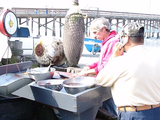
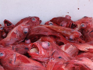
Get there early enough and you will see Dorymen unloading and selling their daily catch in an open air market - north side, foot of the Newport Pier.
This upper commercial / residential section of the Balboa Peninsula thins out as you follow Balboa Blvd. in a more easterly direction once you're past the Spaghetti Factory restaurant on the left
where Balboa and Newport Blvd. merge.
If you come onto the Balboa Peninsula via Newport Blvd., you have easy access to Lido Isle by turning left at Via Lido Way, the first light past the bridge. Once you are on Via Lido Way, this is a great area to explore and eat - but continue on down a curve to the right and then left, across the bridge, onto Lido Isle for a tour of outstanding Lido Isle property.
There are over 850 homes on Lido Isle with an aggregate 2015/2016 value in excess of $2Billion. You will find a little more commentary on Lido Isle at www.LidoIsleProperty.com
Continuing down Balboa Blvd., you will pass the new Marina Park on the left and then arrive at 15th Street. This is another good beach access point - with Newport Bay access as well - on the bay side - next to the American Legion. There are a few shops on the ocean side, a market and, and on the sand
the famous Stuft Surfer café. The only eatery on the Balboa Peninsula allowed to have tables on the sand. Outstanding breakfasts and lunches at reasonable prices.
There is a public restroom facility and outside shower here. Also, parking is more available along the center median as well as on 15th St. Bring a lot of quarters.
A note of caution
this is a deep, beautiful sand beach, but the ocean here is not "people / kid friendly." The beach drops rapidly after entering the water and currents are treacherous. Unless they are "dolphin quality" swimmers - keep a sharp eye on your young ones. Also note that we have lost a number of young adults along here over the years due to rip currents. If you enter the water, do so as a strong swimmer and at your own risk. In season, there are lifeguards posted here. Be sure to check the "water conditions" flag flying from the lifeguard tower... and ask questions if you are uncertain what it means.
A block further, between 14th and 13th Streets, fronting on the boardwalk, is Newport Elementary School
aka "Newport El". Located at 1327 W. Balboa Blvd, this unique elementary school has the main playground on the beach. It was first opened in 1894 and celebrated its first Centennial in June of 1994. It is the only beach front school on the west coast.
Continuing east on Balboa Blvd are high value homes with little commercial enterprise other than the Newport Harbor Yacht Club between 8th and 7th on the bayside of the peninsula - and a restaurant and the Balboa branch of our city library at the north corner of E. Balboa and Island Ave.
Rolling into the 2nd of the two major commercial districts, you hit Palm Street first. This is a traffic light - and you can turn left to the Balboa Peninsula landing of the Balboa Island Ferry service
or right, to a rather large parking lot on the sand. Also at the corner of Palm and E. Balboa Blvd. is another parking lot that used to be home for the Balboa Market - first established in 1938.
Park your car and walk around.
Main attractions here, on the Newport Bay side are the famous Balboa Pavilion, built in 1906 - Balboa Boat Rentals, a number of restaurants
The Landing, and Harborside (located in the Pavilion) restaurants, Davey's Locker passenger fishing service as well as the launch point for the Catalina Passenger Service aboard the Flyer - a large catamaran design hull ferry that takes you on a comfortable trip to Catalina Island.
On the boardwalk (ocean) side of Balboa Blvd. are additional restaurants and bars, the Balboa Pier with a Ruby's Restaurant at the end - and other commercial shops and eateries.
This commercial district is not as large as the first district at the entrance to the Balboa Peninsula - but there is a good deal more history down here. You can tell by the pictures on the walls and the exteriors of some of the remaining historic buildings.
As you leave the commercial district, you'll pass A and B Streets with access to additional parking. If you enroll your child in the summer Junior Lifeguard program, this is where you will pick them up and drop them off.
From B Street on down you enter the Balboa Peninsula Point neighborhood. The homes here cost, for the most part, well into 7 and even 8 figures (2015/2016). The street Letter name designation continues on down to M Street with 4 cross streets and a half dozen or so interior streets. Famous people have lived here including Henry Segerstrom, one of Orange County's most beloved philanthropists, Bill Medley of the Righteous Brothers, Dick Dale of Dick Dale and the Dell Tones, Shirley Temple
and others.
As you remain on E. Balboa Blvd., it curves to the right and eventually brings you to a small park - where you can walk out on the sand (parking permitting) and view the waves of The Wedge - a famous body surfing and body boarding spot. You can then continue to your right on either E. Ocean Blvd or East Ocean Front. Ocean Front has a number of amazing homes fronting on the sand - several of them architectural delights to behold.
Either of these streets brings you back to a right turn onto G Street, where you can then turn left onto E. Balboa Blvd. and head back up the peninsula.
To discuss how you can acquire and utilize this Domain: BalboaTours.com
Contact: Bill Rhinesmith
(949) 307-3013
bill@netpathcom.net
|
|
|
|
|
|